Below is part of an article from 1939 by A Oswald and a 1951 article by H O Houldsworth. Both these articles are contained within the Transactions of the Thoroton Society of Nottinghamshire. For those who are not aware of this Society this is Nottinghamshire principal historical and archaeological society. We are grateful to the Society for permission to publish these articles on our website.
We think that the articles speak for themselves. We would certainly be interested in any information that could be provided in resect of the “raised ridge” mentioned in the 1939 article.
Further commentary will follow in due course.
Transcription:
(1939)
12 SOME UNRECORDED EARTHWORKS IN NOTTS.
………….
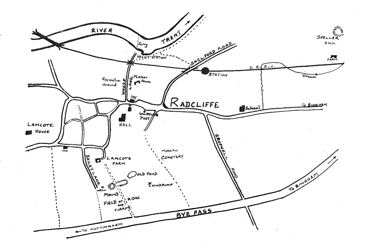
RADCLIFFE-ON-TRENT.
On Malkin Hill, in a commanding position, is a visible round mound. It might be either a barrow or a beacon. There is no trace of a surrounding ditch [43. N.W. 1].
About 150 yards south-west of the church, on lowlying ground, is a mound about 10 yards in diameter and 4 feet high with no sign of an enclosing ditch [43. N.W.5]. –
A raised ridge may be seen running east and west and parallel with the L.N.E.R. line between Radcliffe station and Ash Holt, near the Fosse. It occurs again for about 400 yards south-west of the village, running west-south-west and east-north-east. A section cut near the by-pass showed the ridge to be merely composed of clay with no flanking ditches (43. N.W. 1, 32, 5, N.E.3].
………

(1951)
NOTES ON AN EXCAVATION AT
RADCLIFFE ON TTRENT
By H. O. HOULDSWORTH
SIX miles east of Nottingham lies Radcliffe-on-Trent, which derives its name from the red cliffs by the river.
The village has a long history of settlement from the Bronze Age onwards, and is to-day one of the many “dormitory” villages adjacent to Nottingham.
Much could be written of the history of the 13th century church and the families who owned the land hereabouts after the Norman Conquest, as there is abundant written evidence of their doings and holdings. The archaeological evidence, however, is sparse, and the indications sparser. A mound south by west of the church was recorded by Mr. Adrian Oswald in 1939 (Thoroton Society Trans.) and with the kind permission and co-operation of Mr. G. L. Charlton and his family, I was able to investigate this during the summer of 1951, with a view to ascertaining its origin, purpose and date.”
The mound lies some two hundred yards south by east of Lamcote Farm (MR. O. S. Sheet 121/643 388) and measures 90 feet diameter E/W, height 6–8 ft., and is surmounted by a tall elm tree some 180–200 years old. The farm itself is about the same age.
Fifteen yards (approx.) east of the mound is a rectangular eminence, 241 feet long, 77 feet wide and approx. 3 feet high. Both mound and rectangular earthwork have a deep ditch on the north side, 36 feet wide and 8 feet deep. At the eastern edge of the ditch is a pond, constructed about 100 years ago by the then owner of Radcliffe Hall. –
In addition to the mounds, there were several smaller “tumps” to the west of the circular mound, and the field on the south was constructed of high ridge and furrow, as
* My thanks are due to Messrs. W. Baguley, E. J. Langley and J. Taylor who helped in the excavation, and to Lieut.-Col. N. Lloyd Dexter and Mr. H. Taylor of Radcliffe for items of information which helped to solve points of historical accuracy.
(23)
24 NOTES ON AN EXCAVATION AT
RADCLIFFE-ON-TRENT
far as the bye-pass. A test hole was excavated in the ditch and showed that the ditch had not been stagnant but allowed a clear flow of water through its confines. No relics came from this hole.
In the mound a long trench was dug and at the deeper end, i.e., towards the middle of the mound, dark green pottery, c. 1200, was found at a depth of 1 foot 10 inches, and a presumed post hole roughly 8 inches diameter filled with fragments of skerry (“insignificant sandstone”) and pieces of charcoal at 2 feet 4 inches. No other remains were discovered in this trench. In order to obviate cutting away tree roots, a further hole was dug in the top of the mound and sunk to a depth of 9 feet.
From this hole at a depth of 8 inches was found a
mediaeval tile fragment, and below at 10 inches level
a further fragment of green glaze 13th century pottery as well as a boar’s tusk (age of boar about 3–4 years). The tile is similar in appearance and manufacture to those found at the university tile kiln site excavated by Dr. Swinnerton in 1950. A fragment of an early Tudor brick was found as a scatter.
Beyond these finds, the earth had the appearance of being thrown up from the area of the ditch. The long rectangular mound yielded no satisfactory results, beyond the interesting fact that 19th century pottery fragments were scattered over the surface and it is probable that a certain amount of debris from the pond was spread there at the time of the pond’s construction.
From the evidence and situations of the mounds, one can say that these have the appearance of being motte and baillie type, probably not heavily defended against attack by humans, but well drained against flood. The irregular smaller mounds adjacent to the motte are the only visible remains of the mediaeval huts of the tenants of the lord of the manor. A well, about 8 feet deep still exists, and even after heavy rain, yielded unmuddied water, devoid of insect life and bacterial content.
A section was cut across the ridges and furrows to establish their age and use. This is the first time I have known of this section being taken. The results have been
handed to Dr. J. D. Chambers, of Nottingham University.
25 NOTES ON AN EXCAVATION AT
RAID CLIFFE-ON-TRENT
The section would indicate that the fields were manured with midden refuse and the land reploughed and manured again. From the pottery samples the lower level yielded early 19th century pottery (or late 18th century) and at the upper layer early victorian pottery. Much charcoal was encountered at both these levels.
In the furrows between the ridges, ran a drain pipe of inverted U-type which became popular after 1783 A.D. Before that time the only scientific way of drainage was by the Blith method (after Walter Blith) which was to cut channels in waterlogged land and fill these with faggots or stones. However, a man named Elkington found that by cutting through the clay and inserting a drain, the land could be comparatively drained and used. The inverted U pipe was supposed to be laid on stones but no evidence of this usage was found at Radcliffe. After 1823 round pipes came into general use with cheaper materiai being available. –
The stream, which once supplied water to all Radcliffe, surrounded the motte and acted as a sewer, giving it in later times an unsavoury name, has now been culverted and has its outfall into the Trent. In earlier times it wandered down from Speller Hill (Spel-houe) near Speller Farm to the osier beds by the school, crossed the main road by the chemists shop (Lawn Grove corner) down the roadside to the church, through the vicarage garden to the back of the hall (and probably supplied the pond before-mentioned at the rear of that mansion), whence it turned north across the recreation ground (The Green) and out into the Trent by the old coal wharves. A flood gate was to be found near the present site of the “Whipping Post”.
Leave a Reply